Grand Island
Levee Scour Report
PURPOSE
To provide a time-sensitive synopsis of bathymetric and imaging data so that decision makers and interested stakeholders have an initial grasp of the current condition and susceptibility of potential scouring or toe erosion of the levee system. The survey data also serves to provide a baseline for future change detection of levee scouring.
OVERVIEW
Galindo Construction Company, Inc. and Airborne Technologies, Inc. have teamed up to conduct bathymetric and imaging data surveys of the California Delta rivers and sloughs. The surveys are specifically designed to gather pertinent levee data with remote sensing technologies and to combine that data with local knowledge expertise in order to identify potential levee areas at risk for scouring and/or failure.
Airborne Technologies brings over 30 years of remote sensing survey work of ocean and littoral zones using a combination of satellite, airborne and ship-borne sensors. Galindo Construction brings over 30 years of local Delta area knowledge and understanding of both marine and land based construction projects. In addition, Galindo Construction understands historical water and levee issues from the management perspective as well as the local farmers and land use perspective. The purpose of these surveys is not to duplicate or imitate prior bathymetric surveys that addressed general river concerns but rather to specifically gather data to help identify areas of potential levee scouring.
Our survey methodology can be repeated and will thus provide a baseline year for future change detection.
Illustration 1:
Grand Island as defined by the Sacramento River in yellow and the Steamboat Slough in red. Grand Island has roughly 30 miles of shoreline.
EQUIPMENT
The combined assets of Galindo Construction and Airborne Technologies bring a powerful suite of equipment, experience and knowledge to our disposal in order to design & perform appropriate surveys, gather pertinent data sets and process the data. A sampling of survey equipment is listed below:
Vessels
- 35' Landing Craft w/enclosed cabin
- 24' North River work boat
- 17' “Bass” boat
- 11' Autonomous Research Vessel
- 2' Tethered “Push Broom” platform
Aircraft
- Cessna 185
- Piper PA18
Vessel Survey Equipment
- Sidescan Sonar
- Downscan Sonar
- SST
- Echo Sounder
- Live Scan Sonar
- Multi-beam Sonar
- High Resolution Cameras
- GPS/Compass
- Standard Surveyors Equipment
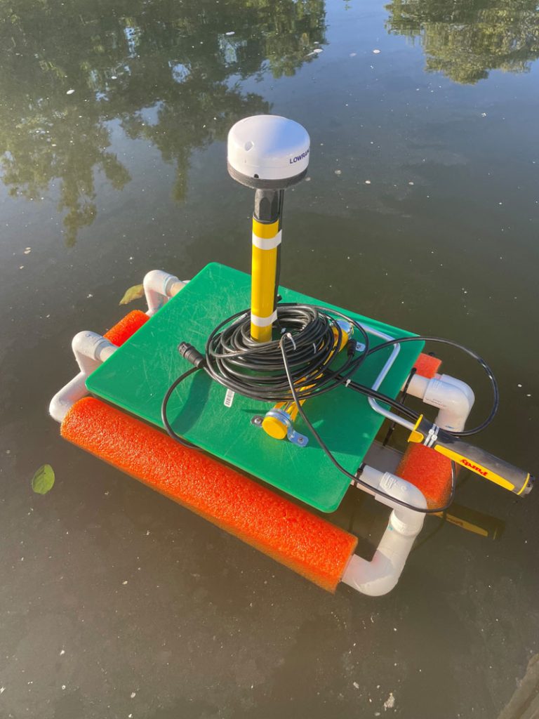
Having a wide array of equipment available allows for creative flexibility in gathering pertinent data. The “push broom” sensor in Illustration 2 was designed specifically to allow the gathering of sonar data right up to the levee edge which is often obscured or blocked by overhanging vegetation and structures making it impossible to use a full size vessel.
In addition to watercraft, we also have aircraft available for gathering aerial imagery should that be useful or necessary.
Post Process Equipment
A variety of software programs are utilized during the post-process analysis of the sonar and image data. These programs include but are not limited to:
- Adobe Creative Suite
- Lightroom
- Photoshop
- Bridge
- QGIS
- Sonar TRX
- ReefMaster
- Google Earth Pro
- ATI's proprietary WebMap
All data is backed up and archived in both the raw format as well as the processed data. ATI’s Webmap allows the end user to access all processed data where they can query and view it online using a secure customer login page.

Illustration 2:
Portable “Push Broom” sensor that consists of GPS/Compass and sonar transducer. The Push Broom is operated from the vessel in order to reach under obstructions and gather bathymetry data immediately up to the levee edge.
SURVEY METHODOLOGY
The vessel used will be determined by the section of water to be surveyed. All appropriate sonar equipment will be installed on the survey vessel. Two personnel will be involved to manage the vessel and the data gathering. Data will be collected during 4 separate parallel tracks that follow the contour of the levee. This is done in order to gather all the appropriate underwater and above water imagery and data. Detailed observation notes are recorded during the transects along with the appropriate GPS locations and images. After the survey is complete, the data is backed up and archived for post-process work. During the post-processing, the data is evaluated for potential areas of levee scouring.
These areas are recorded and noted for further on-water investigation. In addition to levee scouring evaluation, additional datasets of interest are created. The sonar and image data is populated to the customer’s online map page. Postprocess analysis and final report will be completed within 4 weeks of the water survey.

Illustration 3:
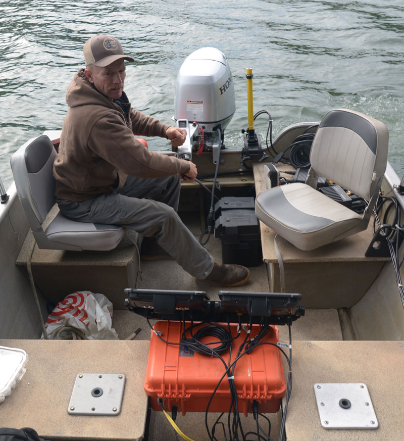
Vessel Operator – Ron Galindo
SAMPLE SURVEY & DATA ANALYSIS
A sample survey was performed June/July, 2022 in the Steamboat Slough and in a section of the Sacramento River near Walnut Grove. These surveys were done in order to identify the appropriate tools and methodologies that could effectively identify areas of concern for potential levee scouring. A variety of sonar technologies were utilized during the surveys and their data-sets evaluated for identifying signatures of potential scouring. The sonar types used included:
- Side-scan
- Multi-beam
- Echo sounder
- Active Imaging live view
- 3D Active imaging
High resolution images were also taken from the vessel of the above water portion of the levee. Both above and below water images and data-sets were recorded with GPS derived position and with heading information provided by a digital compass.
During the survey, the systems operator was tasked with making sure that quality images and sonar data was taken and all relevant levee coastline was covered. The vessel operator was tasked with maintaining proper track and speed of the vessel. Visual observations and anecdotal information were recorded by the systems operator and assigned a digital waypoint. Upon completion of the survey, all data was backed up and set aside for later review. The on-water survey is for gathering primary sonar and imaging data as well as for making GPS location stamped comments and observations. Additional data was gathered by road accessed on-site visits. Aircraft were not used during this sample survey but will be made available for any aerial imagery shots that we deem useful.
The post-processing and data analysis of the sonar data and images revealed considerably more information than that which was observed real-time during the survey. While survey objectivity for this report comes from the sonar data and images, there was subjective interpretation of the data. Since no similar baseline survey has previously been done, change detection conclusions cannot be drawn at this time. However, local anecdotal evidence and historical knowledge can suggest change that is currently happening.
Illustration 4:
Screen shot of post-process software used for viewing the sonar data. Once data is analyzed, Sidescan mosaics are created and uploaded for review on the customer’s map page. The Sidescan image is a pictorial representation of the river bottom in a 2D perspective. Bathymetric charts are also created and uploaded to the customer’s map page.
PROJECT DELIVERABLES
A comprehensive written report will be provided with a detailed list of levee areas that have potential of scouring. The report will include any specific items of concern that need to be brought to the attention of decision makers. In addition, all sonar and image data will be made available on a customer secure online interactive map. If requested, all raw data files will be provided in digital format. Online datasets include:
- 1. Bathymetric map of levee from waterline to 100 ft offshore
- 2. Sidescan image mosaic of river bottom from levee to 100 ft offshore
- 3. Geo-referenced high resolution images of levee from water perspective
- 4. Waypoint datasets that include comments and/or images:
- a. Potential areas of Levee Scouring
- Water level and water current susceptibility
- Beaver dams
- Bank erosion, caving and slope stability
- b. Siphon and Pump locations and images
- c. Areas of interest or concern with attached notes
- d. Derelict vessels
- e. Homeless camps
CONCLUSION
The Delta waterways are the lifeblood of this community. The levee systems must be maintained and monitored in order to protect people, property and commerce.
This survey will help identify potential scouring areas and other areas of concern that are happening today. It also serves as a baseline for future change detection expected with the rapidly changing climate and water issues that California faces.
