Discovery Unmanned Surface Vessel
The Discovery Unmanned Surface Vessel (USV) is an electrically driven small autonomous or remote control vessel. It is relatively compact and lightweight, allowing it to be easily transported or shipped to your project’s location. The reliable electric motor provides quiet environmentally sensitive operations at a low operating cost.

The Discovery USV’s open interior layout area allows for a variety of sensors to be installed. Open source ArduPilot provides a versatile, trusted and proven control system. A variety of communication gear can be added to provide real-time sensor data to the control personnel.
In autonomous mode, the USV is easily controlled and monitored via a Ground Control Station (GCS) that allows for complete pre-route programming and sensor control as well as in-route monitoring or route changes. The GCS can be operated remotely from another vessel or from shore and can also be linked remotely for control through the internet.
Whether it be oceanographic surveys, monitoring tasks, search and rescue, or other remote sensing projects, the USV Discovery can do the job efficiently, effectively and safely.
- Side scan sonar
- Forward scan sonar
- Salinity sensor
- Temperature sensor(s)
- Turbidity
- Ocean color (chlorophyll)
- Pressure
- Hydrophone
- Lidar
Discovery USV Specifications
The Discovery is constructed of marine grade aluminum. It is powered by a Torqedo 8 HP electric motor with a 48v lithium battery pack. Electronics are powered by a 12v battery bank. Solar panels are optional.
Specifications
Performance
Discovery USV Option
Different missions require different sensors. The Discovery is capable of controlling and interfacing with a variety of sensors.
Otolith has built and used custom sensor suites that have included the use of:
- Multi-spectral imagers
- Thermal imaging sensors
- Radiometers (ground or water temperature)
- MicroSAS - ocean color for dissolved organic matter, suspended sediments, and chlorophyll
- Lidar - for finding objects in the water column
Otolith’s engineers can help provide a solution for your specific remote sensing needs including custom communication packages if real-time monitoring of sensor data is required. Our optional OpenIRiS™ software coupled with HD, IR video or high resolution imagery can aid in real-time detection and accurate position of specified targets.
Otolith USVs deliver precise and efficient data collection.
Revolutionizing Hydrographic Surveying with Cutting-Edge USV Technology
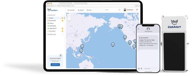
LAD Alert Device
LAD is a self-contained and portable remote monitoring device that continuously monitors and analyzes in-situ data, and using WiFi, cell phone or satellite, sends data to our customers via SMS and email from anywhere in the world.
LAD Remote monitoring devices can play a crucial role in enhancing the USV’s capabilities of in-situ monitoring and data collection. It can help:

Data Collection
LAD enables USVs to collect accurate and detailed hydrographic data, includes depth measurements, underwater topography, and environmental conditions.
Real-time Monitoring
LAD allows operators to monitor the USV’s status and data in real time. This includes tracking the vessel’s location, speed, battery levels, and the quality of the data being collected. Real-time monitoring ensures timely interventions if any issues arise.
Enhanced Accuracy
With high-precision GPS and other advanced sensors, remote monitoring devices help USVs maintain accurate navigation and positioning, crucial for detailed hydrographic surveys.
Autonomous Operations
LAD enables USVs to operate autonomously for extended periods. It can follow pre-programmed routes, adjust to environmental changes, and avoid obstacles without direct human intervention.
We provide hydrographic surveying and consultation services
Service
We provide hydrographic surveying and consultation services, offer safe, efficient, and cost-effective solutions for data collection and operations in water bodies. We conduct surveys using a ship equipped with a range of sensors, including sonar and LiDAR. And, with experienced professionals providing technical solutions, ensures precise, efficient data collection.The hydrological surveying we support include:
- Bathymetric Surveys
- Mapping of the seafloor or riverbed to measure depths and identify underwater features.
- Utilizes advanced sonar and GPS technologies.
- Side-Scan Sonar Surveys
- Produces detailed images of the seabed and submerged objects.
- Used for locating shipwrecks, underwater pipelines, and other structures.
- Sub-Bottom Profiling
- Investigates the layers of sediment and rock beneath the seabed.
- Essential for geological studies and infrastructure projects.
- Hydrographic Data Processing
- Analysis and interpretation of survey data to create accurate maps and models.
- Conversion of raw data into charts and reports for client use.
We also provide consulting services including:
- Project Planning and Feasibility Studies
- Data Interpretation and Reporting
- Environmental Impact Assessments
- Navigational Safety Consulting
Expertise
projects
awards
